Abandoned History: Oldsmobile's Guidestar Navigation System and Other Cartography (Part II)

In last week’s installment of Abandoned History, we learned about General Motors’ 1966 magnet-based primitive navigation system, DAIR. The inclusive system featured emergency messages, traffic bulletins played inside the car, and route guidance. DAIR never progressed beyond the concept stage and two total test vehicles, largely because it would have meant buried magnets and accompanying signal relay stations at every major intersection in the country. Some 25 years later The General tried it again, but technology progressed considerably by that point.
There was notable development in technology, as well as an increased investment by government and private interests in vehicular navigation in the couple of decades after DAIR. The Japanese government engaged in a research partnership on automobile navigation with Fuji in 1973. Shortly thereafter in 1979, Japan’s Ministry of International Trade and Industry founded JSK. The letters translated to the Association of Electronic Technology for Automobile Traffic and Driving, which stated the association’s purpose pretty directly. Japan became the first country to found government initiatives for automobile navigation.
In 1980 Toyota introduced the first electronic compass (Electronic Auto Compass, officially) in the Crown. The following year brought with it the first-ever in-car navigation system when Honda debuted the Electro Gyrocator. Still primitive but very ambitious, the system used inertial navigation rather than satellites. The Gyrocator was developed in conjunction with Alpine, and Stanley Electric.
Limited to the Japanese market, the Electro Gyrocator was offered only on the Accord and Vigor of 1981. The Gyrocator’s helium gas gyroscope necessitated a stationary map in the display, with navigational lights that moved. The 20-pound unit affixed to the top of the dash, and a driver inserted the appropriate map transparency slide for their region of travel that day.
The system worked by measuring the distance and direction from where the car began, as it traveled toward the general endpoint indicated by the driver. There was no way to type in an address, since the system operated without satellites. It was also extremely expensive, at $2,746 in 1981 ($9,714 adj.), or about a quarter of the cost of a JDM Accord. Even Honda isn’t sure how many it sold, as the dealer option appeared in August 1981 and disappeared in 1982.
A few years later, Toyota took the lead when it introduced the first CD-ROM navigation system for the ‘87 Crown. CD- and DVD-based GPS systems use coordinates received from satellites to perform triangulation, and then plot the vehicle’s position on a map. Maps are generally stored by region, and such a system requires several discs to operate. Discs must be swapped out for extended travel.
While DVD-based navigation would exist alongside full-fledged GPS into the 2000s, the latter did not appear until 1990. Mazda offered the first-ever built-in GPS in its high-end (and beautiful) rotary Eunos Cosmo. General Motors was waiting in the wings for the right moment and returned to the navigation fray shortly after Mazda’s introduction.
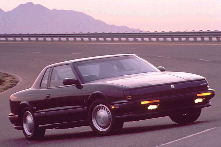
In 1991, GM launched a cooperative in-car navigation project with the American Automotive Association (AAA), Florida’s Department of Transportation, the grand city of Orlando, and rental car company Avis. The subject cars for the project would, as expected, be Oldsmobiles. And not just any Olds model, but the Toronado.
They called it TravTek. The technology was in-car, in-dash, and worked generally like a modern GPS. The Toronado was the natural choice for an in-dash navigation installation, as the luxurious and technical PLC already featured an optional multi-function touch screen in 1991. The navigation module was added to the dash, accessed via an additional NAVIG button to the right of the touch screen, and communicated via satellites with a large (ugly) antenna mounted on the trunk.
There was more to the system though, as wheel sensors were used to relay information on the vehicle’s speed, and a magnetic compass provided directional information that worked in conjunction with the satellite info. General Motors prepared 100 examples of the well-equipped Toronado and divided them up for rental use and as test cars.
Most (75) of the Toronados were distributed via the Avis office at the Orlando International Airport as rentals. The remaining 25 were passed to local drivers who lived in the Orlando area. The system had more features than one might imagine for 1991, and GM spent a lot of effort and money on TravTek. The partnership with the state DoT and AAA was key to the mapping and additional features not offered by other navigation systems of the day.
In our next installment, we’ll cover TravTek’s functionality and its downsides. Unfortunately by the conclusion of the TravTek project, it seemed an ambitious idea that was a bit too much and a bit too soon.
[Images: Honda, Toyota, Mazda, GM]
Become a TTAC insider. Get the latest news, features, TTAC takes, and everything else that gets to the truth about cars first by subscribing to our newsletter.

Interested in lots of cars and their various historical contexts. Started writing articles for TTAC in late 2016, when my first posts were QOTDs. From there I started a few new series like Rare Rides, Buy/Drive/Burn, Abandoned History, and most recently Rare Rides Icons. Operating from a home base in Cincinnati, Ohio, a relative auto journalist dead zone. Many of my articles are prompted by something I'll see on social media that sparks my interest and causes me to research. Finding articles and information from the early days of the internet and beyond that covers the little details lost to time: trim packages, color and wheel choices, interior fabrics. Beyond those, I'm fascinated by automotive industry experiments, both failures and successes. Lately I've taken an interest in AI, and generating "what if" type images for car models long dead. Reincarnating a modern Toyota Paseo, Lincoln Mark IX, or Isuzu Trooper through a text prompt is fun. Fun to post them on Twitter too, and watch people overreact. To that end, the social media I use most is Twitter, @CoreyLewis86. I also contribute pieces for Forbes Wheels and Forbes Home.
More by Corey Lewis
Latest Car Reviews
Read moreLatest Product Reviews
Read moreRecent Comments
- Peter Buying an EV from Toyota is like buying a Bible from Donald Trump. Don’t be surprised if some very important parts are left out.
- Sheila I have a 2016 Kia Sorento that just threw a rod out of the engine case. Filed a claim for new engine and was denied…..due to a loop hole that was included in the Class Action Engine Settlement so Hyundai and Kia would be able to deny a large percentage of cars with prematurely failed engines. It’s called the KSDS Improvement Campaign. Ever hear of such a thing? It’s not even a Recall, although they know these engines are very dangerous. As unknowing consumers load themselves and kids in them everyday. Are their any new Class Action Lawsuits that anyone knows of?
- Alan Well, it will take 30 years to fix Nissan up after the Renault Alliance reduced Nissan to a paltry mess.I think Nissan will eventually improve.
- Alan This will be overpriced for what it offers.I think the "Western" auto manufacturers rip off the consumer with the Thai and Chinese made vehicles.A Chinese made Model 3 in Australia is over $70k AUD(for 1995 $45k USD) which is far more expensive than a similar Chinesium EV of equal or better quality and loaded with goodies.Chinese pickups are $20k to $30k cheaper than Thai built pickups from Ford and the Japanese brands. Who's ripping who off?
- Alan Years ago Jack Baruth held a "competition" for a piece from the B&B on the oddest pickup story (or something like that). I think 5 people were awarded the prizes.I never received mine, something about being in Australia. If TTAC is global how do you offer prizes to those overseas or are we omitted on the sly from competing?In the end I lost significant respect for Baruth.











Comments
Join the conversation
Many decades before GPS I remember going to the ENCO or ESSO then EXXON to get their maps which were Rand McNally maps, then buying the Rand McNally Atlases and getting the Kentucky State Maps at the rest stops. Now I print directions and use my Garmin GPS. My wife's 2013 CRV has the built in navigation but that requires regular updates and even with the updates the GPS doesn't recognize a lot of more recent roads.
As others have commented I miss the cars of the past that had decent size trunks, better visibility, more headroom, and more legroom but I believe we will never see those types of cars again. Auto companies make more money on truck like vehicles. Calling a crossover with a sloped back roof line a coupe is just wrong but many are buying them. Its hard to make a high profile box like vehicle a sporty vehicle even with a sloped roof, a box is still a box. I am expecting a crew cab pickup to have a sloped roof line and be called a coupe. Maybe they could sell that coupe pickup at 100k.
In Southern California in the '80's, the go-to maps were Thomas Guides. Each guide was a spiral-bound collection of street map pages and usually focused on one county per book. I kept LA, Orange and Ventura county guides in the car at all times. I see on Amazon that they're still in print!